
Planning a Practical Multi-Destination Backpacking Route
To plan a practical multi-destination backpacking route, plot every chosen stop, lock the start, end and fixed commitments, group nearby stops, and order those groups in a broad travel direction. Then test each leg for door-to-door travel time, transfers, schedules, border or connection constraints, and detours; revise the order when the friction is disproportionate unless a fixed constraint clearly justifies the extra movement.
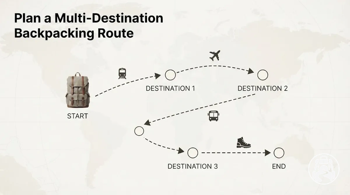
Route-order decision loop
Build the route from constraints first, then use real connection conditions to decide whether the provisional order should stay or change.
- Plot every chosen stop. Put all destinations on one map so relative position, proximity and isolation are visible.
- Lock the anchors. Mark the start, end and any fixed-date or non-negotiable stops before moving flexible destinations.
- Form geographic clusters. Group nearby stops that share a useful regional relationship or corridor, including sensible cross-border groupings.
- Choose a broad direction. Order the clusters so the route generally progresses without unnecessary reversals.
- Check every route leg. Compare map distance with realistic door-to-door time, transfers, schedules, border conditions and connection friction.
- Correct the exceptions. Reorder avoidable zigzags and detours; retain extra movement only when a fixed stop, gateway, priority or connection constraint justifies it.
Keep the orderwhen direction and connection practicality both work.
Revise the orderwhen a flexible sequence creates disproportionate time, transfers or repeated movement.
Keep an exceptionwhen changing the order would break a real route constraint or a higher-priority commitment.
The task here is route construction: turning already chosen destinations into a workable order. Destination selection, detailed transport booking, day-by-day pacing and itinerary-flexibility decisions are separate planning stages.
The map supplies a provisional sequence; the practical route is the sequence that still works after the traveller's time limits, transfers, timetables, border conditions and local connection patterns are checked.
Table of Contents
Build the Route Around a Clear Geographic Sequence
Arrange the already chosen destinations into a provisional geographic sequence before evaluating individual transport connections.
The initial route order should reveal a clear travel direction while leaving room for fixed commitments and later connection checks to change the sequence.
Sequencing the destinations first makes the overall route shape visible and can expose unnecessary reversals before detailed travel legs are considered.
The visual below shows how the same destination markers can move from an unordered set to a directional sequence without changing which destinations are included.

Use location, proximity, fixedness, and regional relationship to determine the provisional route order.
Fixed stops such as the start point, end point, or an immovable commitment constrain the sequence, while movable stops can be reordered around those anchors when their geographic position supports a clearer path.
- Map the chosen destinations. Place every selected stop on one map so relative location, proximity, and the overall route shape are visible.
- Identify the constraints. Mark the start point, end point, and fixed stops before moving destinations that still have sequencing flexibility.
- Form geographic groupings. Group stops that share proximity or a practical regional relationship so nearby destinations can be processed together.
- Order the groups. Arrange the groups in one general travel direction while respecting fixed stops and the geographic position of each group.
- Inspect the overall path. Look for reversals, isolated jumps, or changes in direction that indicate the provisional stop order should be reconsidered.
For example, suppose the same four hypothetical stops A, B, C, and D lie progressively along one general direction.
A → B → C → D produces a cleaner geographic shape than A → C → B → D, which introduces a reversal unless a fixed commitment justifies it.
The resulting geographic sequence is still provisional and must be verified against the practical connections for each travel leg before the route order is treated as workable.
Plot the Chosen Destinations on One Map Before Sequencing Them
Plot every chosen destination on one map before assigning a final route order.
Seeing all destination markers together reveals relative position, proximity, separation, corridors, and the overall route shape that a list of place names cannot show as clearly.

Scan the mapped destinations for spatial relationships that could affect later sequencing.
Visual proximity may suggest that stops belong near each other in the route order, but map distance alone does not establish travel time or connection practicality.
Geographic barriers can separate apparently nearby stops, while corridors can reveal a natural directional relationship between several destinations.
Isolated stops can also indicate where the route shape may require a larger detour or a different position in the sequence.
- Relative position: note which destinations lie north, south, east, or west of the other stops and how those positions shape the overall route.
- Proximity: identify destination markers that appear close enough to consider together, while leaving actual connection feasibility for later verification.
- Corridors: look for several stops aligned along the same broad geographic direction or natural route corridor.
- Geographic barriers: note borders, coastlines, mountains, water crossings, or other separations that may make visual closeness misleading.
- Isolated stops: identify destinations separated from the main group because their position may create a detour or influence where they fit in the route order.
For example, two hypothetical destinations may look close when considered separately, yet plotting every chosen stop together may show that they sit on opposite sides of the emerging route shape or are separated by a geographic barrier.
The map therefore provides a spatial basis for sequencing, while the practicality of each connection still needs to be checked separately.
Mark the Starting Point, End Point, and Fixed Stops
Mark the starting point, end point, and genuinely fixed stops before ordering the movable stops.
These route constraints act as anchors: each fixed location reduces the number of valid route orders, while destinations without fixed commitments can still be repositioned around them.
The image below distinguishes those non-negotiable route points from stops that remain movable.

The key distinction is whether changing a stop would break a real route constraint or simply change a preference.
A starting point fixes where the route begins, an end point fixes where it must finish, and fixed-date stops constrain where certain destinations can appear in the sequence.
Movable stops retain sequencing freedom and can be reordered when doing so produces a more coherent route around the fixed anchors.
- Starting point: fixes the first route position and limits which destinations can logically follow from the initial location.
- End point: fixes the final route position and constrains how the remaining stops can approach that destination.
- Fixed-date or non-negotiable stops: anchor specific locations within the route order when an existing commitment genuinely prevents them from moving.
- Movable stops: remain flexible and can be reordered around the fixed constraints when another sequence better fits the route.
For example, suppose the same destinations are used in two hypothetical trips, but one trip starts in city A and ends in city D while the other starts in city D and ends in city A.
The valid route order can reverse because the route boundaries have changed, even though the destination set is identical.
Marking those constraints first prevents the flexible stops from being sequenced around assumptions that no longer apply.
Group Nearby Destinations Into Regional Clusters
Group nearby destinations into regional clusters when their proximity and practical geographic relationship make them function as one route segment, before those clusters are ordered.
The image below shows how neighbouring stops, including stops across a border, can form a coherent cluster around shared geography or a common corridor while a more isolated destination sits outside that grouping.

Regional clusters should reflect geographic relationships rather than country labels alone.
Proximity, shared corridors, border continuity, adjacency, and relative isolation are the main signals for distinguishing coherent regional groupings from isolated stops.
These signals suggest which nearby destinations should usually be processed together before the route moves to a more distant geographic area, although actual connection practicality still requires later verification.
- Proximity: nearby destinations are stronger candidates for the same regional cluster when their positions form a compact geographic area.
- Shared corridor: stops aligned along the same broad corridor may function as one group when the corridor provides a plausible connection path.
- Border continuity: neighbouring destinations on opposite sides of a border can still belong to the same cluster when their geographic relationship remains coherent.
- Adjacency: destinations positioned next to the same regional group can support that cluster even when political boundaries differ.
- Isolation: a stop separated from the surrounding destinations suggests a cluster boundary and may be better treated as part of another regional grouping.
For example, two hypothetical cities located close together on opposite sides of a national border may form a more coherent regional cluster than two cities in the same country that are widely separated.
The border does not determine the grouping by itself; the cluster-level implication comes from proximity, corridor continuity, adjacency, and relative isolation.
Order Clusters in One General Travel Direction
Arrange established clusters so the route generally progresses in one general travel direction and avoids unnecessary reversals.
An east-to-west, north-to-south, or loop-shaped directional sequence can provide that structure, depending on the cluster positions and route boundaries.
The graphic below compares two orders of the same clusters to show how route direction changes the number of reversals.
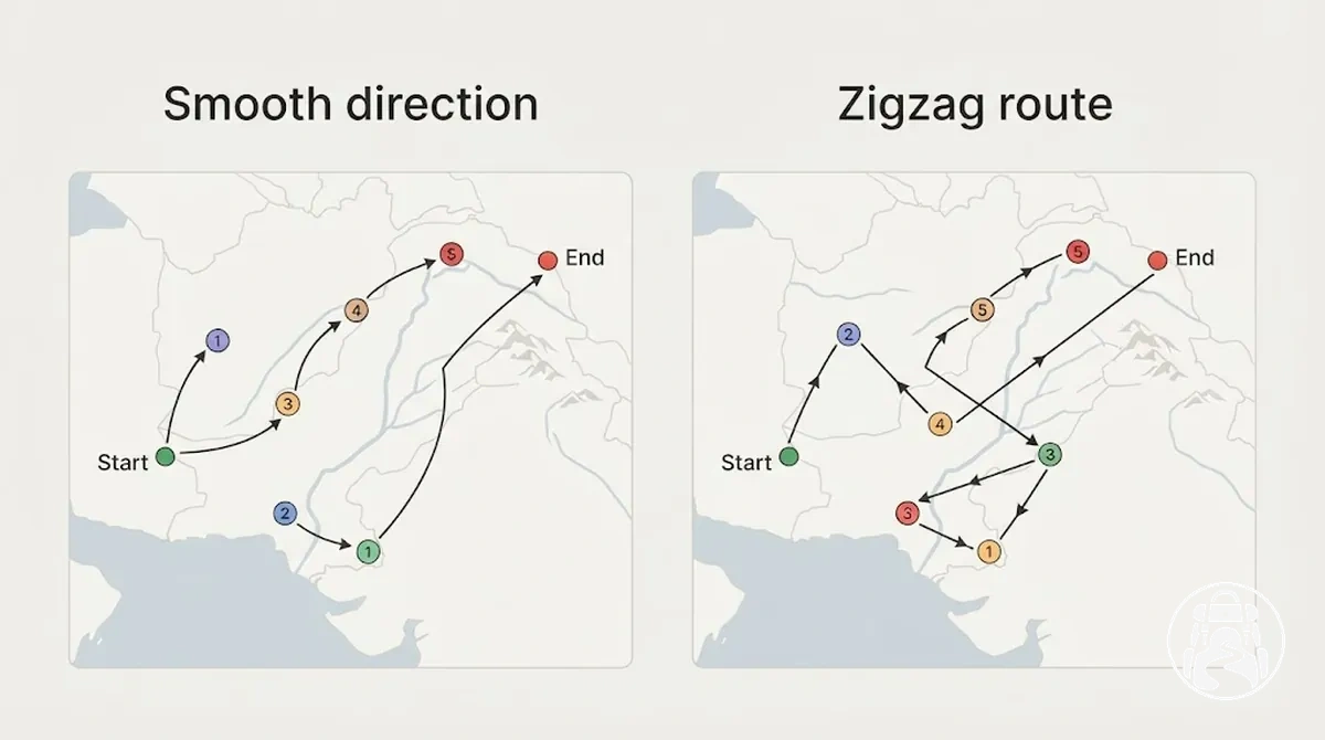
A general travel direction is a routing heuristic rather than an absolute rule.
Fixed stops, route boundaries, or difficult connections can justify a deviation, so the aim is to identify unnecessary reversals without assuming that the shortest geometric path is always the most practical route order.
- Test a broad direction. Arrange the clusters in an east-to-west, north-to-south, or simple loop sequence that broadly matches their geographic positions.
- Inspect the route progression. Trace the cluster order from the starting point to the end point and note where the route continues in the same broad direction or turns back across earlier ground.
- Check each reversal. Reconsider a reversal when another cluster order can avoid it without conflicting with fixed stops or known connection constraints.
- Retain justified exceptions. Keep a deviation when a fixed stop or difficult connection makes the less direct directional order more practical than a smoother geometric sequence.
For the same hypothetical clusters A, B, C, and D, A → B → C → D shows smooth route progression when the clusters lie in that directional order, whereas A → C → B → D creates a zigzagging reversal.
The second sequence is not automatically wrong, but the reversal should have a specific constraint or connection reason rather than occurring by accident.
Sequence Multi-Country Stops Through Adjacent Regions
Sequence a multi-country route through adjacent regions and the actual positions of selected stops rather than treating each country as one indivisible route block.
The diagram below shows why cross-border routing should follow stop location and shared-border geography instead of country names alone.
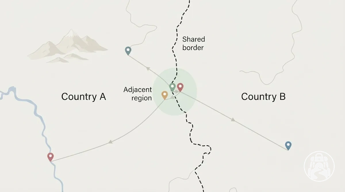
Border adjacency matters only when the selected stops also have useful geographic continuity across that border.
Neighbouring countries do not automatically create neighbouring stops: selected cities may sit far from their shared border, while stops in adjacent border regions may form a more coherent cross-border sequence.
Cross-border continuity should therefore be treated as conditional on stop position and the practical path between those stops.
Border formalities or connection limitations only need to change the route order when they materially affect whether that sequence is feasible.
- Identify adjacent regions. Note which parts of each country meet or lie close enough geographically to support a plausible continuation of the route.
- Locate the selected stops. Compare each stop location with the shared border and neighbouring regional stops rather than assuming country adjacency equals stop adjacency.
- Test cross-border continuity. Check whether the proposed sequence creates a practical geographic progression across the border or forces a large deviation away from the adjacent regions.
- Keep or revise the sequence. Retain the country-to-country order when stop positions support continuity; revise it when the selected stops make another cross-border route order more coherent.
For example, two hypothetical neighbouring countries may share a border, yet the selected city in each country could lie far from that border on opposite sides of their respective territories.
In that case, sequencing those cities consecutively may create an inefficient cross-border jump, even though the countries themselves are adjacent.
Check Whether Each Route Leg Is Practical
A geographically tidy sequence is useful only if each route leg remains practical when treated as a real journey rather than a line on a map.
Evaluate the travel burden of every connection in the wider route context, because distance alone does not show how much travel time, connection friction, or usable trip time the leg may consume.
Test each route leg against the same practical criteria so map-level attractiveness can be compared with real-world connection practicality.
Distance, realistic travel time, transfers, departure and arrival friction, detour size, and usable trip time can each change whether the current route order still makes sense.
Travel time should be checked against current schedules where possible because timetables, seasonal service, and operating conditions can change.
- Distance: a shorter geographic distance may support keeping the route order, but distance alone is not enough when the actual connection requires a substantial detour.
- Travel time: consider the realistic end-to-end travel time rather than only the time spent moving between terminals; a leg that consumes a disproportionate share of usable trip time may support revising the order.
- Transfers: each required transfer adds another connection point and may increase the practical burden of the route leg, especially when several changes are needed for an otherwise simple geographic move.
- Departure and arrival friction: terminal access, inconvenient departure or arrival conditions, and movement between connection points can make a seemingly straightforward segment more demanding than its map position suggests.
- Detour: a connection that requires substantial movement away from the intended route progression can indicate that the current sequence should be reconsidered, unless another route constraint justifies it.
- Usable trip time: judge how much of the traveller's available time the route leg consumes relative to the value of keeping that stop in its current position; a high time burden can make a geographically neat order less practical.
A route leg is low-friction when these criteria collectively impose little disruption on the wider route, while an acceptable leg may involve some transfers, detour, or time cost without materially weakening the sequence.
When several criteria combine to create disproportionate travel time or connection friction, that pattern suggests revising the route order rather than applying a universal numeric threshold.
Detailed transport choices belong to the separate transport-planning stage rather than this route-level practicality check.
For example, a hypothetical route leg may look close on a map but require several transfers, indirect terminal access, and a large detour.
That combination can make the leg disproportionately burdensome in usable trip time, giving a practical reason to test a different route order even though the geographic sequence initially appeared tidy.
Compare Geographic Distance With Real Travel Time
A shorter geographic distance does not necessarily produce a shorter real travel time for a route leg.
An apparently close stop can require more connection time, transfers, terminal access, or waiting than a longer-looking leg with a more direct connection, so map distance and door-to-door time should be evaluated separately.
Real travel time reflects the full journey burden rather than distance alone, with transfers, waiting, terminal access, traffic, border processing, schedules, and seasonal service potentially changing the result.
The table compares qualitative route-leg patterns so apparent proximity can be weighed against usable day loss without inventing fixed journey times.
| Route Leg | Map Distance | Connection Pattern | Real Travel-Time Factors | Route Implication |
|---|---|---|---|---|
| Shorter but indirect leg | Relatively short | Multiple transfers or indirect connection | Transfer waits, terminal access, connection time, and schedule variability can increase usable day loss | Consider revising the route order if the total time burden is disproportionate to the apparent geographic advantage |
| Longer but direct leg | Relatively long | More direct connection | Fewer transfers and simpler terminal access can reduce connection friction, although schedules and operating conditions still matter | The route leg may remain practical when its door-to-door travel time fits the wider route better than the shorter alternative |
For example, a hypothetical longer-looking route leg with a direct connection can take less real travel time than a geographically shorter leg that requires several transfers and lengthy terminal access.
The comparison does not establish a universal rule: current schedules, traffic, border processing, seasonal service, and local connection conditions can change which leg creates the greater usable day loss and whether the route order should be kept or revised.
Identify Awkward Connections, Dead Ends, and Large Detours
An awkward connection is identified by patterns of disproportionate route friction rather than distance alone.
A repeated reversal, dead end, large detour, deceptively short but time-heavy link, or connection requiring many transfers is a diagnostic signal that the route leg warrants closer examination, but none of these patterns by itself establishes that the stop or sequence is inefficient.
The diagnostic flow separates each warning sign from its likely routing implication before a route decision is made.
- Repeated reversal
- Check whether a fixed commitment or route boundary requires the repeated segment.
- Decision direction investigate revising the sequence when no such justification exists.
- One-stop out-and-back branch
- Check whether the isolated stop serves a fixed commitment or unique priority.
- Decision direction retain it when the added friction is justified; otherwise test another order.
- Large detour
- Check whether geography or another constraint makes the deviation necessary.
- Decision direction consider revision when the detour has no clear routing reason.
- Short distance, heavy travel time
- Check transfers, waiting, terminal access and the actual connection pattern.
- Decision direction test an alternative sequence when the time burden is disproportionate.
- Repeated transfers
- Check whether the changes are unavoidable for the selected stops.
- Decision direction use the pattern to review the route order rather than treating transfer count alone as a verdict.
For example, a hypothetical out-and-back stop can be acceptable when it is tied to a fixed event or a unique priority that justifies returning along the same route.
The same dead-end pattern is more avoidable when the stop is flexible and another cluster sequence can reach it without the repeated segment.
The diagnosis is therefore whether the signal has a specific justification; an unexplained pattern of reversal, detour, or connection friction warrants further review for possible revision, while a justified exception may remain.
Test Alternative Stop Orders With Mapping Tools
Use mapping tools and route-planning tools to test alternative stop orders, not to decide the route without context.
They can display how candidate sequences change distance, travel time, waypoints, and alternative paths, while the traveller still needs to judge whether the resulting stop order fits fixed stops, practical connections, and the wider trip.
The most useful functions are those that let the same set of stops be rearranged and compared consistently.
Tool capabilities and limitations can vary by route mode, waypoint support, schedule coverage, and location, so displayed results should support route reasoning rather than act as an automatic answer.
- Plot all stops: display the selected destinations together so competing stop orders can be tested against the same geographic context.
- Reorder waypoints: rearrange waypoints where the tool permits it and compare the resulting route shape; waypoint limits or mode availability may restrict the test.
- Compare distance: compare candidate orders for backtracking or detours, while recognising that shorter distance alone does not establish the more practical sequence.
- Compare travel time: compare available travel-time estimates between candidate orders, but interpret them conditionally because route mode, schedules, traffic, and coverage can affect the result.
- Check alternative paths: inspect alternative routes where available, then use traveller judgment to decide whether a more direct-looking path still fits fixed commitments and real connection conditions.
For example, a hypothetical order A → B → C → D can be tested against A → C → B → D using the same stops, route mode, distance view, and available travel-time information.
If one candidate reduces backtracking but conflicts with a fixed stop or depends on an unsuitable connection, the mapping result should inform the route decision rather than override that context.
Resolve Backtracking, Zigzags, and Inefficient Detours
Backtracking, a zigzag, a large detour, or a repeated reversal is a symptom that needs interpretation before correction.
These patterns may reflect a poor sequence that creates avoidable repeated movement, but they can also result from route constraints that make the detour necessary.
Avoidable backtracking usually results from a poor sequence that sends the route across the same area or direction more than necessary, so reordering may reduce the repeated segment.
Justified backtracking can occur when a fixed gateway must be used twice, a limited connection forces travel through the same point, or a high-priority stop requires a temporary departure from the broader route direction.
In those cases, retaining the repeated movement can be more appropriate than forcing a geographically cleaner route shape.
The troubleshooting sequence is Symptom → Likely Cause → Check → Correction, which separates routing errors from necessary detours before choosing a corrective direction.
Troubleshooting path
- Symptom Zigzag or repeated segment Likely cause: a poor stop sequence. Check: whether changing the order preserves fixed gateways, limited connections and priority stops. Correction: reorder the affected stops when the reversal is avoidable.
- Symptom Detour through the same gateway Likely cause: a structural connection constraint. Check: whether another usable path exists without disrupting required stops. Correction: retain the detour when the fixed gateway or limited connection makes it necessary.
- Symptom Reversal around a flexible stop Likely cause: the stop's position in the sequence. Check: whether moving the stop removes repeated movement without creating another routing problem. Correction: use the revised order when it produces a more coherent route without breaking necessary constraints.
For example, consider the same hypothetical stops A, B, C, and D.
A route ordered A → C → B → D may create a zigzag if B lies between A and C, while changing the sequence to A → B → C → D can remove the repeated movement without changing the destination set.
The adjustment is appropriate only when no fixed gateway, limited connection, or priority-stop constraint justifies the original detour.
Distinguish Necessary Detours From Avoidable Backtracking
Not every reversal is inefficient. The same repeated movement can be avoidable backtracking when a flexible stop is poorly placed, or a necessary detour when a fixed gateway, fixed commitment, limited connection, or high-priority stop makes the repetition the more practical choice.
Avoidable backtracking
- Typical condition
- A flexible stop or cluster creates a repeated segment without a fixed route reason.
- Test
- Try another order while keeping the same required stops and practical connections.
- Decision
- Revise the order when the alternative removes the reversal without creating a new constraint.
Necessary or justified detour
- Typical condition
- A fixed gateway, fixed date, limited connection, or high-priority stop requires the route to repeat or deviate.
- Test
- Check whether a cleaner-looking order would break that constraint or create a worse practical connection.
- Decision
- Keep the detour when the extra movement is the consequence of a real constraint rather than an accidental sequence.
The practical test is simple: if another stop order removes repeated travel while preserving fixed anchors and workable connections, the backtracking is likely avoidable. If every cleaner geometric order breaks an important constraint, the detour may be the correct route shape.
Simplify Isolated Stops That Require Long Out-and-Back Travel
When the baseline route is already coherent, an isolated stop that creates substantial out-and-back travel should be evaluated as a local optimization problem rather than as a reason to rebuild the whole route.
The decision is whether the stop's detour time and route friction are justified by its priority, uniqueness, fixed commitments, or the possibility of repositioning it more cleanly.
Assess how much extra travel burden the isolated stop adds, whether the stop has a fixed commitment or unusually high stop priority, and whether another position in the sequence could absorb it without creating excessive reversal elsewhere.
The appropriate outcome depends on those conditions rather than on remoteness alone.
- Keep: retain the isolated stop when its stop priority, uniqueness, or fixed commitments justify the added detour time and out-and-back travel, and no cleaner sequence materially reduces that route friction.
- Reposition: move the isolated stop within the existing sequence when an alternative position can absorb the branch with less reversal or travel burden without disrupting fixed commitments or creating another inefficient leg.
- Remove: consider removing the stop from the current route when it remains flexible, adds disproportionate route friction, has relatively low priority, and cannot be repositioned without preserving much of the same detour burden.
For example, a high-priority isolated stop tied to a fixed event may justify a long branch even when the main route must temporarily reverse direction.
A similarly isolated but low-priority stop with no fixed commitment may be a stronger candidate for repositioning or removal if the same route cannot absorb it more cleanly.
The practical choice is therefore conditional: keep, reposition, or remove the isolated stop according to its detour burden, importance, and constraints rather than applying one universal rule.